The Kerguelen Islands sit in the southern Indian Ocean, far below the main shipping lanes, far from large cities, far from commercial airports and far from any normal idea of an island escape.
Wrong turn approved.
A French Archipelago Very Far From France
The Kerguelen Islands are French territory, but they do not belong to the familiar map of France most people imagine.
They are not in Europe.
They are not in the Caribbean.
They are not in the Mediterranean.
They are not near Réunion in any practical travel sense, even though Réunion is an important logistical connection.
They lie deep in the southern Indian Ocean, in a cold, windy, subantarctic zone. The archipelago forms one district of the Terres australes et antarctiques françaises, usually abbreviated as TAAF in French.
This makes Kerguelen one of the strangest pieces of France on the planet: legally French, geographically isolated and environmentally closer in mood to the edge of Antarctica than to the Côte d'Azur.
Mila: "You said French islands."
Vera: "They are French."
Mila: "I packed for pastries."
Vera: "There may be wind."
What Is the Main Island?
The largest island in the archipelago is called Grande Terre.
That name means "large land" in French, and here it is very literal. Grande Terre dominates the archipelago, with deeply cut bays, peninsulas, cliffs, volcanic landscapes, glaciers, mountains and coastlines shaped by rough southern seas.
It is not a small tropical island you can casually walk around.
Kerguelen is an archipelago built from distance and scale:
- one large main island,
- hundreds of smaller islands and islets,
- long, broken coastlines,
- fjords and sheltered bays,
- volcanic terrain,
- cold water,
- very few human structures.
The landscape looks empty at first glance. But that emptiness is deceptive. The coasts and surrounding seas are full of wildlife, and the islands are scientifically important because of their isolation and relatively limited human disturbance.
What Is Port-aux-Français?
Port-aux-Français is the main base on the Kerguelen Islands.
It is often described as the main settlement, but that can be misleading if you imagine a normal town. Port-aux-Français is better understood as a scientific and technical base.
It supports research, logistics, environmental monitoring, communications, maintenance and field operations. The number of people there changes by season and mission. They are generally scientists, technicians, support staff and administrators rather than a permanent civilian community.
Mila: "Where is the cute old town?"
Vera: "That building has laboratories."
Mila: "Where is the café street?"
Vera: "Still asking tropical questions."
Port-aux-Français exists because Kerguelen matters for science, logistics and environmental monitoring — not because it is easy or comfortable to live there.
Can You Fly to the Kerguelen Islands?
No. There is no commercial airport on the Kerguelen Islands.
That single fact explains a lot.
Most remote places become psychologically easier once you can imagine a runway. Flights create the illusion of access: inconvenient, expensive, maybe rare — but still possible.
Kerguelen does not offer that comfort.
Access is by sea, generally through authorised logistical or research operations. The French supply and research vessel Marion Dufresne plays a major role in connecting the French southern islands, including Kerguelen, with the outside world.
That means Kerguelen is not a place where you simply search for flights, compare hotels and book a long weekend.
It is a place where access depends on permission, purpose, planning, ships and weather.
This is not a destination you "pop over" to.
This is a destination that makes logistics the main character.
Why Are the Kerguelen Islands So Remote?
Kerguelen is remote because it is far from almost everything that usually makes a place accessible.
It is far from continents. It is far from major cities. It is far from airports. It is far from normal shipping routes. It is far from casual tourism infrastructure.
But remoteness is not only about distance on a map.
On Kerguelen, remoteness means:
- supplies must be planned far in advance,
- weather can affect fieldwork and unloading,
- travel depends on ships,
- there is no easy emergency exit,
- there is no neighbouring town,
- equipment matters,
- mistakes become logistical problems.
A forgotten cable, a delayed shipment or a damaged piece of gear can matter much more here than it would in a city.
That is what makes Kerguelen different from a remote-looking place that still has a road, a shop and an airport within reach.
Kerguelen is not just far away.
It is structurally far away.
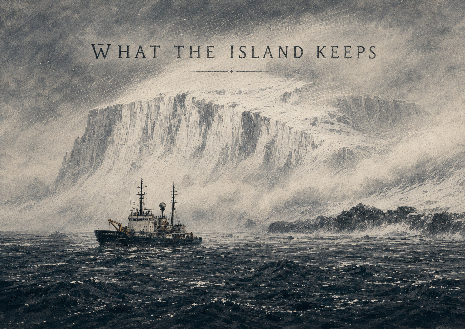
Why Did Captain Cook Call Them the Desolation Islands?
The Kerguelen Islands are also known as the Desolation Islands.
That nickname is strongly associated with Captain James Cook, who visited the archipelago during his third voyage in 1776. Cook had not discovered the islands — the French navigator Yves-Joseph de Kerguelen-Trémarec had reached them earlier in 1772 — but Cook mapped and described parts of the archipelago and helped make its reputation known to the English-speaking world.
The name "Desolation Islands" makes immediate emotional sense.
Kerguelen is treeless, exposed and dominated by wind, rock, cold water and low vegetation. For sailors arriving after weeks at sea, hoping for shelter, supplies or signs of warmth, the landscape must have seemed brutally unwelcoming.
No forests.
No villages.
No cultivated fields.
No easy landing.
No obvious comfort.
Just weather, cliffs, seals, birds and a landscape that looked like it had no interest in humans.
The name was not a scientific description. It was a sailor's reaction.
And honestly, it stuck because it works.
Is "Desolation" Fair?
Yes and no.
From a human comfort perspective, the word fits. Kerguelen is cold, windy, isolated and difficult to access. It is not generous to people looking for warmth, shade or convenience.
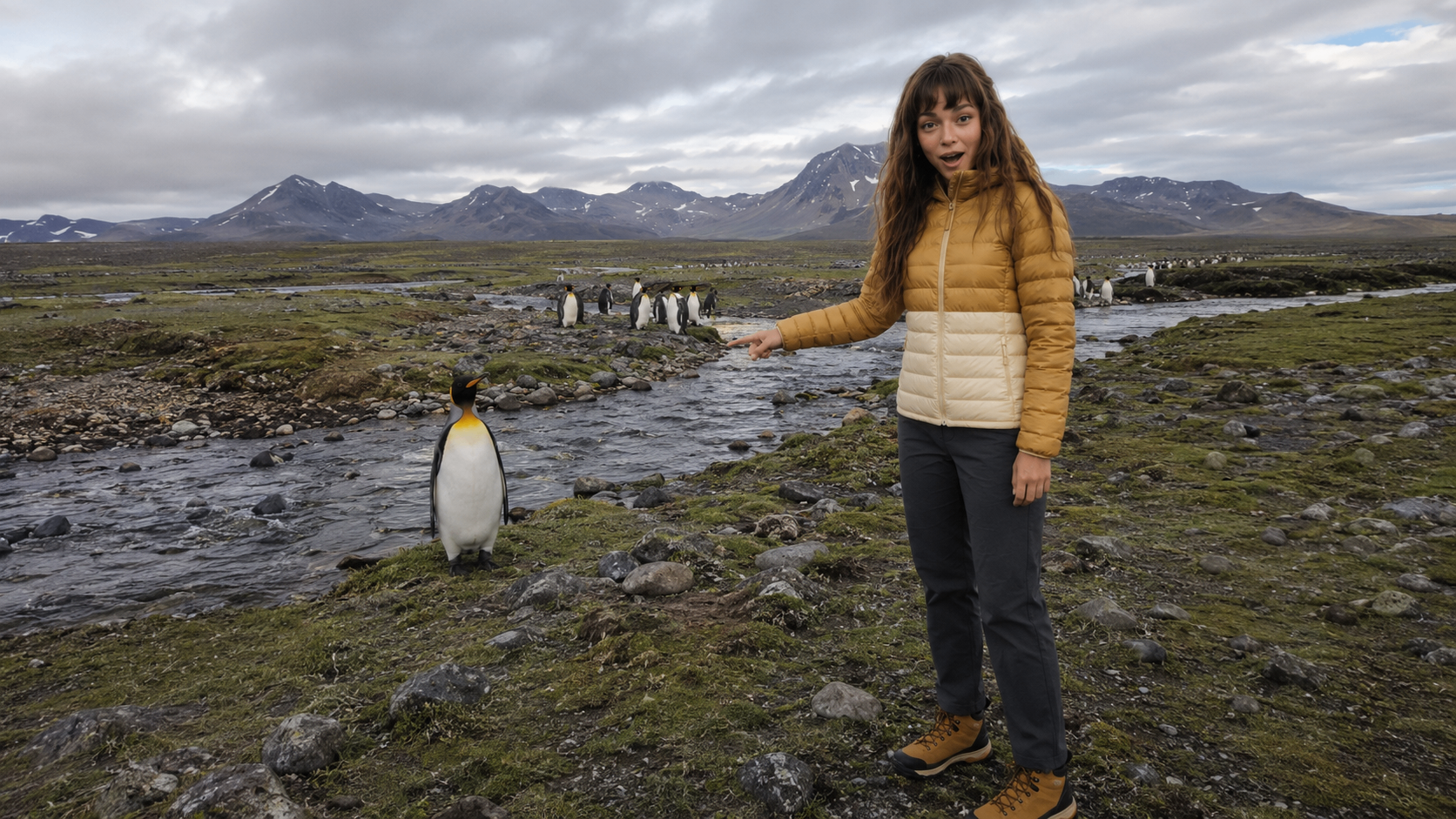
But ecologically, "desolation" is misleading.
The islands and surrounding seas support major populations of birds and marine mammals. Penguins, albatrosses, petrels, seals and other species use this remote region in large numbers. The wider French Austral Lands and Seas are recognised for their biodiversity, conservation value and importance to scientific research.
So Kerguelen is desolate only if the measure is human convenience.
For wildlife, it is not empty at all.
It is busy, loud, alive and deeply important.
Desolate for cafés. Extremely busy for penguins.
Is Kerguelen Near Antarctica?
Kerguelen is subantarctic, not Antarctic.
That distinction matters.
The islands are located in the southern Indian Ocean, north of Antarctica, in a cold and stormy oceanic region influenced by the Southern Ocean. They are not part of the Antarctic continent, and they are not covered by the Antarctic Treaty in the same way as Antarctic territories.
But emotionally and environmentally, Kerguelen often feels closer to Antarctic imagination than to the Indian Ocean most people picture.
When people hear "Indian Ocean," they may think of warm beaches, coral reefs and tropical islands.
Kerguelen is the opposite version of the Indian Ocean:
- cold,
- windy,
- rugged,
- subantarctic,
- volcanic,
- remote,
- difficult to reach.
It is the Indian Ocean after the music stops.
Who Lives on the Kerguelen Islands?
There is no permanent civilian population on the Kerguelen Islands.
People do stay there, but mainly as part of scientific, technical, administrative and logistical missions. The population changes with the seasons and the work being carried out.
That makes Kerguelen very different from Tristan da Cunha, which has a permanent local community, or Ittoqqortoormiit, which is a remote inhabited settlement.
Kerguelen has human presence, but not ordinary civilian life.
There are no families who have lived there for generations in a normal village structure. There is no school district, no elected local town community and no casual island lifestyle.
Instead, there is mission life:
- research,
- maintenance,
- logistics,
- monitoring,
- fieldwork,
- shared facilities,
- long rotations,
- serious weather.
For Wrong Turn Right, this creates a different kind of story. Vera and Mila are not walking into a hidden town. They are entering a remote operational world where every human activity has a reason.
Why Are the Kerguelen Islands Important?
Kerguelen matters because it is remote, protected and scientifically valuable.
The archipelago and surrounding seas offer a rare environment for studying:
- marine ecosystems,
- seabird populations,
- seal populations,
- climate,
- ocean systems,
- geology,
- invasive species,
- long-term environmental change.
Remote places like Kerguelen act like natural laboratories. Their distance from major human activity makes them valuable for observing ecological processes that are harder to study in more disturbed environments.
This is why Kerguelen should not be treated only as an "empty weird place."
It is not just a dramatic backdrop.
It is part of one of the most important protected natural regions in the southern Indian Ocean.
How Big Are the Kerguelen Islands?
The archipelago is larger than many people expect.
Grande Terre, the main island, is large and deeply indented by bays and peninsulas. Around it are hundreds of smaller islands and islets. On a map, Kerguelen does not look like a simple island. It looks like a broken piece of land scattered by weather.
That geography matters because it makes travel inside the archipelago difficult.
Distances are not just measured straight across land. They are shaped by:
- bays,
- fjords,
- rough coastlines,
- cliffs,
- wetlands,
- mountains,
- glaciers,
- weather,
- sea conditions.
This is one reason why Kerguelen can feel even larger than it is.
The terrain does not invite shortcuts.
What Does Kerguelen Look Like?
Kerguelen looks like the opposite of a travel brochure cliché.
There are no palm trees.
No turquoise lagoon.
No beach umbrellas.
No resort skyline.
Instead, the visual language is:
- dark volcanic ground,
- low vegetation,
- mosses and grasses,
- cliffs,
- cold bays,
- grey-green hills,
- glaciers,
- low cloud,
- abandoned industrial remains,
- seabirds,
- seals,
- wind moving through everything.
It is not conventionally pretty in the tropical sense.
It is cinematic, severe and strange.
The kind of place where the landscape does not pose for you. It just continues being itself while you struggle with your jacket.
Why Kerguelen Works for Wrong Turn Right
Kerguelen is almost too perfect for Wrong Turn Right because the real facts already sound like an exaggerated AI prompt.
- A French island with no normal town.
- A scientific base instead of a village.
- No airport.
- A ship as the main connection.
- A nickname like "Desolation Islands."
- Penguins, elephant seals, wind, ruins and research equipment.
- A landscape that looks abandoned even when it is scientifically active.
The key joke is simple:
Mila hears "French islands" and imagines the wrong genre.
Vera hears "French islands" and books the most punishing possible interpretation.
Mila: "I thought this would be romantic."
Vera: "It is. Just not for humans."